Anguienne Valley
-
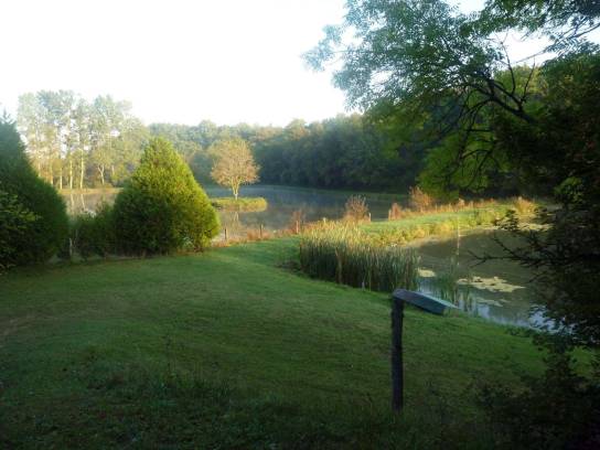 Photo creditJack maLicenseCC BY-SA 3.0
-
 Photo creditJack maLicenseCC BY-SA 3.0
-
 Photo creditGoogle streetLicenseAll rights reserved
-
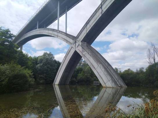 Photo creditAxelMax75018LicenseCC BY-SA 4.0


About
The Anguienne Valley is a small limestone valley on the outskirts of Angoulême. Between Soyaux, Dirac and Garat, the river flows through a landscape of contrasts, where the wet areas at the valley floor sit alongside limestone slopes, cliffs, caves and former quarries. This interplay between rock, water and vegetation gives the site a particularly distinctive character.
The valley also has a history linked to the use of its natural resources: the old quarries and hydraulic structures, notably the mills, bear witness to the human activities that have developed around the river. The themed trail in the lower part of the valley now allows visitors to explore these landscapes in an easily accessible setting.
Discover
Landscapes and natural environments
The valley’s landscape is characterised by a stark contrast between:
- the damp valley floor, associated with the River Anguienne and waterlogged soils;
- the limestone slopes, which are drier and more exposed, featuring cliffs and rocky outcrops;
- the old quarries and cavities, which contribute to the site’s mineral character;
- woodlands and alluvial formations, which are more lush in the wetter areas;
- thermophilic limestone grasslands, particularly characteristic of dry, sunny areas.
The GrandAngoulême Inter-municipal Biodiversity Atlas explicitly identifies the Anguienne Valley as a limestone valley combining xerothermophilic grasslands, dry and damp cliffs, caves and springs.
Fauna and flora
The valley forms a mosaic of habitats conducive to a diverse range of biodiversity. The Anguienne area is notably part of the ecological corridors of the limestone valleys surrounding Angoulême.
The presence of the European pond turtle has been documented in the Anguienne Valley area, particularly around the Châtelard pond in Dirac. The Atlas identifies it as a biodiversity hotspot for wetlands. Naturalist monitoring of this species is currently ongoing at the Natura 2000 site.
The valley’s diverse habitats also support flora and fauna associated with dry limestone environments, wetlands, woodlands and aquatic habitats. However, it is important not to attribute all the species recorded across the vast Natura 2000 site to the valley alone.
Ecological and heritage value
The Anguienne Valley is a Type I ZNIEFF (Site of Natural Interest for Flora and Fauna) No. 05930017, referenced as FR540003213. It is described as a site combining several remarkable habitats: thermophilic grasslands, cliffs, caves and springs.
It also forms part of the Natura 2000 site ‘Limestone valleys around Angoulême’, which covers a wider area comprising eight municipalities and includes, in particular, the Anguienne, Eaux Claires and Charreau valleys.
Finally, the valley plays a role in the region’s Green and Blue Infrastructure. The Atlas highlights the overall importance of the valleys and aquatic environments of the Pays d’Angoulême as key elements in ensuring ecological connectivity.
Explore
Things to see and explore
- The limestone cliffs and outcrops on the hillsides.
- The old quarries and caves.
- The contrast between the dry hillsides and the damp valley floor.
- The wooded areas and the vegetation of the wetlands.
- The course of the River Anguienne and its banks.
- The wildlife of the wetlands, including the opportunity – though sightings are not guaranteed – to look for traces or suitable habitats for the European pond turtle.
- The Anguienne viaduct, visible from certain sections of the route.
Exploring the site
An Anguienne Valley Trail is directly linked to the site. It is an easy walk of around 3 km, taking about 1 hour 30 minutes. The lower part of the valley is ideal for a family outing and can be explored by bike or scooter.
There is also a longer ‘Anguienne Fountains Circuit’, approximately 8.5 km long, which allows you to explore the area more extensively. However, this is a hiking route and not the nature site itself.
Seasonality
- Spring is a particularly good time to observe the vegetation on the hillsides and enjoy the contrasts between the dry areas and the damp valley floor.
- Early summer is also a good time to observe insects and the vegetation on the limestone grasslands, whilst the wooded areas offer a cooler environment.
- Autumn offers a chance to discover a different atmosphere in the valley, particularly in the woodland and wet areas.
- After heavy rain, conditions in the valley floor may be different. The valley is covered by a Flood Risk Prevention Plan.
Conservation and best practice
- Stay on the designated paths and in authorised areas.
- Do not enter caves or disused quarries when they are not open to the public.
- Do not disturb wildlife, particularly in wetland areas.
- Do not pick wild plants.
- Keep dogs under control and observe any local regulations.
- Do not leave any rubbish behind.
- Following heavy rainfall, be aware of conditions in the valley floor and any access restrictions.
Practical information
- Access: there are several entry points to the valley; the themed trail is linked in particular to the Saint-Marc/Soyaux area.
- Recommended spot: the area around the Saint-Marc road in Soyaux.
- Trails: Anguienne Valley Trail, 3 km, approx. 1 hr 30 mins, easy – Anguienne Fountains Circuit.
- Accessibility for people with reduced mobility: varies; the natural features and terrain mean accessibility varies depending on the area.