La Nouère
-
 Photo creditPère IgorLicenseCC BY-SA 4.0
-
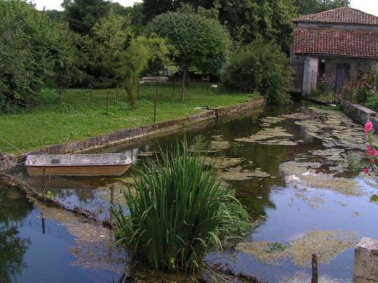 Photo creditRosierLicenseCC BY-SA 3.0
-
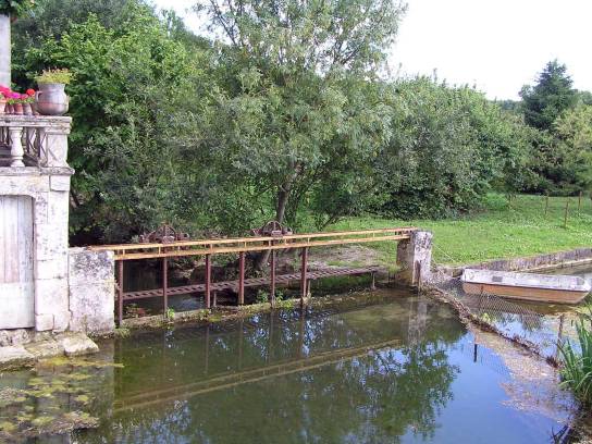 Photo creditRosierLicenseCC BY-SA 3.0


About
The Nouère is a small river in the Charente region and is one of the right-bank tributaries of the Charente in the western part of Angoulême. Approximately 25.8 km long, it flows through a predominantly rural landscape before joining the Charente at Linars, downstream from Angoulême. It forms part of the Charente catchment area and is of particular importance for migratory fish and ecological continuity.
Discover
Geography
The Nouère rises in the commune of Rouillac, at a place called Le Temple, at an altitude of approximately 114 meters. It flows generally south-southeast towards Angoulême.
Its course, approximately 25.8 km long, ends at Linars, where it flows into the Charente on the right bank, near Fleurac, at an altitude of about 25 m. Its catchment area is relatively small, covering an area of approximately 118 km².
The river has an oceanic rainfall regime. Its course is quite meandering; its width is generally around 5 meters and its average gradient is approximately 0.3 per cent. Depending on the section, depths observed during normal periods can vary from approximately 0.20 to 2 meters, particularly depending on the weirs present along its course.
The Nouère is classified as a Category 1 fishing water, characteristic of watercourses where salmon fishing predominates.
Hydronymy
The name ‘Nouère’ is an ancient one. Several forms are attested in the Middle Ages, notably ‘super Noiram’ in 852, ‘fluvium Nodra’ in 879 and ‘fluvium Noira’ after 942.
The etymology generally proposed links the name to the Old French word ‘nouère’, associated with the idea of a dark or black color. This interpretation should, however, be treated with caution: the exact origin of the hydronym has not been fully established.
The river’s name has been passed on to several place names: Saint-Amant-de-Nouère, Asnières-sur-Nouère and the canton of Val de Nouère.
Towns and villages through which it flows
From source to mouth, the Nouère flows through or runs alongside the following municipalities:
- Rouillac – source area;
- Saint-Cybardeaux;
- Saint-Genis-d’Hiersac;
- Saint-Amant-de-Nouère;
- Asnières-sur-Nouère;
- Saint-Saturnin;
- Linars – the point where it joins the Charente.
It is therefore an important hydrographic feature of the Val de Nouère, particularly between Rouillac and the Angoulême conurbation.
Tributaries
Hydrological data are not entirely consistent across different sources.
SANDRE does not currently list any major tributaries officially linked to the Nouère. However, documents detailing the river’s hydrology identify several small watercourses or local tributaries.
These include:
- the Fontguyon, a right-bank tributary, which is approximately 8 km long;
- the Asnières stream, approximately 2.5 km long;
- a small watercourse fed in particular by the springs of Font de Grosville, Font de Bonneuil and Font Franchaud, which joins the Nouère at Saint-Cybardeaux.
Cassini’s map also mentioned a stream called the Fondion, corresponding to the Fontguyon area, whose course could become seasonal and then continue through a dry valley.
Flora and fauna
The Nouère is of significant ecological importance despite its modest size.
Its status as a Category 1 river makes it of particular interest for fish found in running waters. Species identified as conservation priorities include, in particular:
- brown trout;
- the sculpin;
- Planer’s lamprey;
- the dace;
- sea trout, the migratory form of trout.
Historically, runs of sea trout have been reported in the Nouère, including near the bridge on the RN141. More recent documents also continue to list the Nouère amongst the tributaries of the Charente frequented by this species.
Habitats associated with the river include riparian woodland, wet meadows, ditches, pools and other environments linked to the groundwater table. These areas play a role in the natural purification of water, the regulation of flow and the support of biodiversity.
The vegetation along the banks comprises, in particular, stands of ash, willow, alder and hornbeam, accompanied by hedgerows and wet herbaceous vegetation depending on the area. The Nouère valley has also been identified locally as a wetland eco-complex of ecological interest.
Developments
The Nouère has been significantly influenced by both historic and modern hydraulic works.
Several weirs and structures associated with old mills still alter water levels and flow locally. These structures historically enabled the use of hydropower, but they can act as barriers to fish migration and the natural transport of sediments.
Restoration work has therefore been undertaken to improve ecological connectivity. In particular, work has focused on several structures located in the downstream section of the river, with the aim of facilitating fish migration and restoring more diverse habitats.
Road infrastructure, notably the RN141, also crosses the Nouère. Crossing facilities and wildlife passages have been installed as part of the road infrastructure in the area.
History
The Nouère has long been a small river closely linked to rural life.
Its waters and banks were notably associated with the cultivation of hemp. Several old retting pits still bear witness to this activity. Retting was used to separate the fibers from the plant before they were used in textiles.
The river also powered numerous water mills. Some have disappeared, whilst others have been converted into dwellings, but traces of them remain in the landscape and place names. The history of the Nouère’s mills bears witness to a long-standing milling tradition that was particularly significant between the 17th and 19th centuries.
This history partly explains the presence of weirs, millstreams and diversions that still characterise certain sections of the river.
Heritage
The heritage associated with the Nouère consists mainly of a collection of small hydraulic and rural features:
- old watermills;
- canals and hydraulic structures;
- wash houses;
- fountains and springs;
- old hemp retting pits;
- bridges and crossing structures;
- historic dwellings and hamlets situated near the river.
In Asnières-sur-Nouère, in particular, several features directly associated with the river are noted: a washhouse situated in the bed of the Nouère at the foot of Neuillac, another near Salzine, and the remains of an old mill.
The Nouère’s hydraulic heritage thus bears witness to the historical use of water for domestic, agricultural and craft activities.
The valley
The Nouère valley forms a relatively narrow landscape corridor between the limestone plateaus to the west and north-west of Angoulême.
It alternates between meadows, farmland, riparian woodland, hedgerows and wetlands. Near the riverbed, the presence of the accompanying groundwater table helps to maintain environments that are cooler and more humid than on the surrounding plateaus.
In Asnières-sur-Nouère, the valley has notably been described as a wetland eco-complex of ecological interest, with issues relating to riparian woodland, woodlands and agricultural areas.
A distinction must therefore be made here between the Nouère itself—the watercourse—and the valley, which constitutes its geographical and ecological environment.
Protection
The Nouère benefits from several management and protection measures linked to its ecological role.
It is covered by the Charente SAGE, a planning framework designed in particular to ensure the quantitative and qualitative protection of water resources and aquatic environments. The Charente EPTB is responsible for implementing this policy across the catchment area.
From a regulatory perspective, the Nouère is classified under the ecological continuity framework. It is listed in List 1, which prohibits the construction of new structures that obstruct ecological continuity, and certain sections are also covered by List 2, which requires the maintenance or restoration of the movement of migratory fish and the transport of sediments.
The river is also a key route for migratory fish, with particular concerns regarding eels and sea trout.
Protection also relies on the conservation of wetlands, riparian forests and aquatic habitats, as well as on measures to restore water flow and habitats.