Charente
-
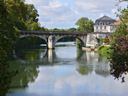 Photo creditJLPCLicenseCC BY-SA 3.0
-
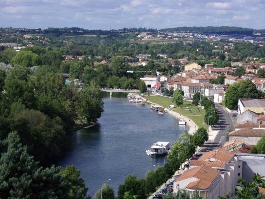 Photo creditJLPCLicenseCC BY-SA 3.0


About
The Charente is a major river in south-western France. It flows through three departments (Haute-Vienne, Vienne and Charente-Maritime) as well as the department of Charente, to which it has made a direct contribution in shaping its layout. It rises in the Limousin region and flows into the Atlantic Ocean via a vast estuary between Port-des-Barques and Fouras. The Sandre gives its length as 381 km.
Discover
Geography
The Charente rises at Chéronnac, in Haute-Vienne, at an altitude of approximately 295 meters. It initially flows north-west, then crosses the southern part of the Vienne, before entering the Charente, where it becomes the department’s main watercourse.
Its course continues notably through Ruffec, Mansle, Montignac-Charente, Angoulême, Châteauneuf-sur-Charente, Jarnac and Cognac, before entering Charente-Maritime and flowing into the Atlantic Ocean.
Its catchment area covers approximately 10,000 km² and its flow regime is of the oceanic pluvial type. The river flows relatively slowly and is highly sinuous, characterised by numerous meanders, secondary branches, islands and wetlands.
In the Angoulême region, the Charente flows for approximately 40 km and is joined, in particular, by the Touvre, the Anguienne, the Eaux Claires, the Charreau, the Nouère, the Boëme, the Claix, the Argence and the Vélude.
Hydronymy
The name ‘Charente’ is very ancient. The river is mentioned in antiquity in its Greek form, Kanentelos, and later in the Latin form Carantonus by the poet Ausonius in the 4th century.
Medieval forms include, notably, Karente in 799, Karantona in 874 and Carentum in 891.
The exact origin of the name remains a matter of debate. Two main interpretations are put forward:
- a Gallic origin linked to the root ‘karant-’, which may evoke the idea of ‘to love’ or ‘to be dear’;
- an older origin linking the name to a term meaning ‘sandy’, which would have conveyed the idea of a ‘sandy river’.
Towns and villages through which it flows
The Charente flows through or borders a very large number of towns. Its course includes, in particular:
Haute-Vienne: Chéronnac, Rochechouart and the towns in the upper valley area.
Vienne: Charroux, Civray, Chatain and several municipalities in the Charente valley.
Charente: Confolens, Ansac-sur-Vienne, Verteuil-sur-Charente, Condac, Ruffec, Aunac-sur-Charente, Mansle, Montignac-Charente, Vars, Saint-Yrieix-sur-Charente, Gond-Pontouvre, Angoulême, Fléac, Linars, Saint-Michel, Trois-Palis, Nersac, La Couronne, Sireuil, Roullet-Saint-Estèphe, Châteauneuf-sur-Charente, Saint-Simeux, Saint-Simon, Angeac-Charente, Vibrac, Jarnac, Bourg-Charente, Cognac and Javrezac, amongst others.
Charente-Maritime: the Charente continues its course, notably through Saint-Savinien, Taillebourg, Saintes, Chaniers, Port-d’Envaux, Tonnay-Charente and Rochefort, before reaching its estuary and the Atlantic Ocean.
This list deliberately focuses on the main towns directly associated with the river and does not constitute an exhaustive cadastral register of all the towns whose territory is affected by its course or its tributaries.
Tributaries
The Charente has a particularly extensive network of tributaries.
Main left-bank tributaries
- the Tardoire, together with the Bandiat;
- the Bonnieure;
- the Touvre;
- the Anguienne;
- the Eaux Claires;
- the Charreau;
- the Boëme;
- the Né;
- the Seugne;
- the Arnoult.
Main tributaries on the right bank
- the Aume;
- the Nouère;
- the Soloire;
- the Antenne;
- the Boutonne.
The Touvre is a particularly remarkable tributary: it is fed by groundwater from the La Rochefoucauld karst and is one of the main resurgences in France.
Flora and fauna
The Charente forms a remarkable ecological system thanks to the diversity of its habitats: flowing and still waters, oxbow lakes, wet meadows, reed beds, marshes, alluvial woodlands and vegetated riverbanks.
Among the heritage species recorded in the various Natura 2000 sites are, in particular:
- the European kingfisher;
- Graslin’s damselfly, a dragonfly associated with watercourses;
- the European shad, a migratory fish;
- the European mink, which is particularly threatened;
- the Greater Horseshoe Bat;
- the marsh harrier;
- the red-backed shrike;
- the Alpine longhorn beetle;
- the Estuarine Angelica.
Migratory fish are also a major concern. However, the presence of numerous weirs and dams along the Charente river system disrupts their movement, despite the installation of fish passes and restoration works.
Developments
The course of the Charente has been extensively modified over the centuries.
These include, in particular:
- weirs and dams;
- locks;
- old water mills;
- quays and harbours;
- docks and old towpaths;
- structures designed to facilitate navigation;
- fish passage facilities;
- flood protection works.
Recreational boating is now permitted from Angoulême to the estuary. In the Charente department, the state-owned section extends in particular between La Boixe/Montignac-Charente and the border with Charente-Maritime.
However, the river remains prone to flooding. Navigation may be prohibited, in particular, when the water level exceeds the regulatory threshold set at the Angoulême-Saint-Cybard gauge.
History
The Charente has been a route for settlement and travel since prehistoric times. Its banks have yielded numerous archaeological finds attesting to an ancient human presence.
In the Gallo-Roman period, the river was already an important transport route. Saintes, Cognac and Jarnac served as ports at that time.
In the Middle Ages, the Charente became a vital trade route between the inland regions and the Atlantic coast. Salt, cereals, wine, stone and various other goods were transported along it.
From the early modern period onwards, and particularly in the 17th and 18th centuries, gabarres transported the brandies produced in the Cognac region to the ports on the Atlantic coast. They also travelled upriver carrying goods from the coast.
In the 19th century, major works further improved navigation conditions: quays, weirs, locks, slipways and port facilities were modernised. In Cognac, the quays were notably expanded to support the boom in the spirits trade.
With the development of the railways and roads, commercial river transport gradually declined. The Charente nevertheless retains its appeal for tourism, its scenic beauty and its water sports.
Heritage
The Charente boasts a particularly rich heritage.
In Angoulême and the Pays d’Angoulême
The river is intimately linked to Angoulême, whose urban layout was shaped by its meanders. Even today, it continues to define the landscapes of Saint-Yrieix-sur-Charente, Gond-Pontouvre, Fléac, Nersac and the riverside towns and villages.
River villages and towns
Several towns have built their history around ports, bridges and mills: Verteuil-sur-Charente, Mansle, Montignac-Charente, Châteauneuf-sur-Charente, Jarnac and Cognac.
Cognac
In Cognac, the river has played a decisive role in the town’s development. The harbour, the quays, the old warehouses and the wine cellars bear witness to its commercial past.
River heritage
The heritage includes, in particular:
- historic quays;
- harbours and docks;
- mills;
- locks;
- dams;
- bridges;
- towpaths;
- boatmen’s cottages;
- warehouses and wine cellars;
- traces of the activity of the bargemen.
Part of this heritage is now incorporated into walking routes and the Flow Vélo cycle route, a section of which follows the old towpath.
The valley
Whilst not constituting a site distinct from the river itself, the Charente valley encompasses all the areas shaped by the river and its floods: the floodplain, wet meadows, side channels, marshes, alluvial woodlands and farmland.
The landscapes vary greatly from one area to another: a steep-sided or narrow valley in some places, wide floodplains around Angoulême and Cognac, and then vast wetlands and marshes further downstream.
Between Angoulême and Cognac, the valley and several tributaries form a vast Natura 2000 site covering 5,373 hectares spread across 53 municipalities.
Protection
Protection of the Charente relies primarily on the Natura 2000 network, supplemented by water regulations, the management of aquatic environments and measures to restore ecological connectivity.
Several Natura 2000 sites are directly related to the river:
- The Charente Valley upstream of Angoulême;
- The Charente Valley between Angoulême and Cognac and its main tributaries;
- The middle Charente Valley and the Seugne;
- The middle Charente Valley, the Seugne and the Coran;
- The Charente Valley (lower valley).
The DREAL lists, in particular, the ZSC FR5402009 site, covering the valley between Angoulême and Cognac and several of its main tributaries, as well as Special Protection Areas (SPAs) covering various sections of the river.
The main challenges are the preservation of floodplain meadows and wetlands, water quality, the conservation of alluvial habitats, the protection of threatened species and the restoration of ecological continuity, particularly for migratory fish.
Within the Greater Angoulême area, the management of aquatic environments and flood prevention fall specifically within the remit of GEMAPI.