City Walls
-
 Photo creditJack maLicenseCC BY-SA 3.0
-
 Photo creditJack maLicenseCC BY-SA 3.0
-
 Photo creditJack maLicenseCC BY-SA 3.0
-
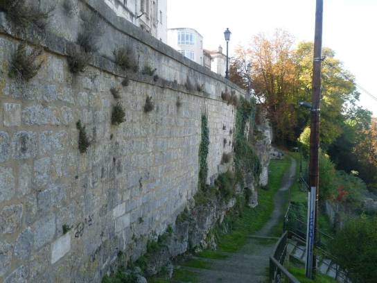 Photo creditJack maLicenseCC BY-SA 3.0
-
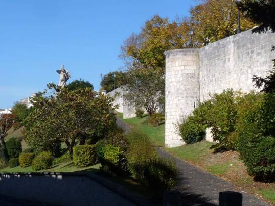 Photo creditJack maLicenseCC BY-SA 3.0


About
The ramparts are one of the defining features of Angoulême’s landscape. Situated on a limestone promontory overlooking the Charente, the historic town is naturally protected by steep slopes, to which the fortifications added a man-made defence. The historic plateau remains recognisable today by this silhouette surrounded by ramparts.
The preserved complex bears witness to several phases of fortification. The Ministry of Culture identifies, in particular, an initial enclosure dating back as far as the 4th century, followed by medieval extensions, notably from the late 12th century and throughout the 13th century.
Not to be missed
- The remains of the first enclosure in the covered market area.
- The towers and curtain walls still visible around the plateau.
- The unobstructed views from the ramparts over the Charente valley and the landscapes to the south-west.
Discover
A town built on a rocky outcrop
Angoulême owes much of its identity to its topography. The historic centre occupies a rocky promontory rising to a height of around 125 metres, towering some 70 metres above the Charente valley. To the south, the Anguienne valley further accentuates the natural isolation of this rocky outcrop.
This location explains the distinctive layout of the old town. The ramparts follow the edges of the plateau and have long dictated the flow of traffic. The presentation report on this outstanding heritage site thus describes a traffic system largely organised around the plateau and the boundaries set by the fortifications.
History
The Ministry of Culture’s listing identifies several successive phases in the development of the ramparts.
An initial fortification was erected on the rocky ridge. It may date back to the 4th century. Its course followed the cliff face from the castle area, before turning southwards. The construction combined large stone blocks with reused elements from earlier buildings.
Square towers were subsequently added to this initial enclosure, probably in the 11th century. By the end of the 12th century, the defences were extended to encompass the New Castle and to strengthen the defences of the eastern part of the town.
At the end of the 13th century, the growing importance of the Saint-Martial suburb led to a further extension of the defences. Curtain walls and semi-cylindrical towers were then built around the area corresponding, in particular, to the present-day Champ de Mars.
Much of this fortification has since disappeared. The Ministry of Culture notes, however, that several fragments of curtain walls and towers have been preserved, some of which still feature embrasures for cannons.
Timeline
- 4th century - The first wall: A wall was erected on the rocky ridge. Some remains are still visible in the area of the covered market.
- 11th century - Reinforcement: Two square towers were probably built to flank the curtain wall.
- Late 12th century - Extension: The defences were extended to protect the new castle and the eastern part of the town.
- Late 13th century - Protection of Saint-Martial: A new wall encloses the Saint-Martial suburb and connects to the castle area.
- Modern era - Transformation of the town: The fortifications gradually lost their defensive function. Urban development spread into the former glacis after the ramparts were lowered and the gates demolished.
- 20th century - Heritage protection: The remaining ramparts and towers were listed as historic monuments on 18 December 1958.
Architecture and heritage
The ramparts do not constitute a uniform wall built in a single period. Rather, they form a collection of remains that reveal the various stages in the defensive evolution of Angoulême.
The first enclosure is characterised in particular by large blocks of cut stone laid in courses. Its infill incorporated architectural elements from older structures: fragments of columns, bas-reliefs, capitals and statues.
The medieval fortifications subsequently introduced various flanking features: square towers, semi-cylindrical towers, curtain walls and defensive openings.
A heritage closely linked to the landscape
The ramparts are not merely a succession of walls. They also provide a way of interpreting the topography of Angoulême.
From the top of the plateau, the slope of the terrain down towards the Basseau bend opens up distant views to the west and south-west. To the north, the Charente valley also offers sweeping vistas.
This relationship between the fortifications, the terrain and the panorama helps to explain the scenic appeal of this historic site.
Did you know?
The famous ‘Jambe de Clovis’, visible on the southern rampart, recalls a tradition linked to Clovis’s siege of Angoulême. However, the wall on which this sculpture now stands is a 13th-century enclosure, whereas the episode attributed to Clovis is said to have taken place in front of an older enclosure. The exact origin of the relief therefore remains uncertain.
Explore
Guided tour
- Start at the historic plateau
First, take in the location of the upper town: the terrain explains why Angoulême was such a prime defensive site. - Look for traces of the ancient ramparts
In the covered market area, parts of the original fortifications are still visible. These provide an insight into the ancient phase of the ramparts’ history. - Take a look at the towers
Not all the towers date from the same period. Some are part of the successive medieval defences that reinforced the curtain walls. - Follow the line of the ramparts
This route helps you understand how the fortifications hugged the edge of the plateau and made direct use of the terrain’s natural features. - Turn to look at the landscape
From the higher vantage points, look out over the Charente, the valleys and the surrounding plateaus. The landscape immediately reveals the site’s strategic importance.
Look here
- The stone blocks of the first enclosure: their masonry reveals an ancient construction method.
- Traces of the towers: these show how the curtain walls were flanked and guarded.
- The defensive openings: some of the surviving towers still bear traces of their military function.
- The terrain beneath the ramparts: the steep slopes explain why the fortifications were built on the edge of the plateau.
Then / Now
- Yesterday: the ramparts defined the physical boundary of the fortified town and controlled access to it.
- Today: they form a series of ruins integrated into the urban fabric. The town’s development has gradually caused much of the enclosure to disappear, whilst certain sections have been preserved and protected.
This remarkable heritage site now encompasses almost the entire historic plateau, whose skyline remains characterised by its relationship with the ancient fortifications.
The hidden detail
On the southern rampart, look out for the sculpture known as the ‘Leg of Clovis’. It should not be taken as physical evidence of the historical episode with which it is traditionally associated: its presence on a 13th-century rampart is precisely what sustains the mystery surrounding its origin.
The ramparts and their surroundings
The fortifications form the boundary of the historic centre and link several heritage districts: Old Angoulême, the Cathedral district, the Prefecture area and the former Saint-Martial suburb.
Exploring them can therefore be combined with a stroll through the upper town, linking the defensive remains with monuments, historic streets and vantage points.
Nearby
To be completed depending on the chosen starting point for the route:
- Saint-Pierre Cathedral
- Town Hall and former castle
- St Andrew’s Church
- Saint-Martial Church
- The walls of Épernon
- Watchtower on Rue de Bélat
- Old Angoulême
Several of these buildings feature on Angoulême’s list of historic monuments. For example, Saint-Pierre Cathedral has been listed since 1840, whilst the Épernon city walls have been listed since 1972.
Continue the tour
To gain a proper understanding of the ramparts as a whole, it is best to continue your walk across the plateau rather than examining each ruin in isolation. The terrain, the monuments and the former defensive boundaries all form part of the same historical landscape here.